Geography Fieldwork Gwaith Maes Daearyddiaeth
English
Cymraeg
The aim of this digital resource is to guide you or your students through the steps involved in creating a good geographical enquiry title.
Each section builds on the contents of the previous one to lead to the generation of a suitable enquiry title.
The resource also assists in the identification of what data needs to be collected, the methodology and sampling strategies as well as how the data can be presented and analysed.
Activities are included in the resource to guide you to ask questions about what you are doing and why it is relevant to the enquiry title you are considering.
Each section includes text boxes into which content necessary for the enquiry planning sheet will be entered by the participant. This information can then be printed off and used in the planning stage of the enquiry process.
Additional information on specific terminology can be accessed by rolling over words which are in bold and underlined.
Nod yr adnodd digidol hwn yw eich tywys chi neu'ch myfyrwyr drwy'r camau i'w dilyn i lunio teitl da ar gyfer ymholiad daearyddol.
Mae pob adran yn seiliedig ar gynnwys yr adran flaenorol er mwyn arwain at lunio teitl addas ar gyfer yr ymholiad.
Mae'r adnodd hefyd yn helpu i nodi pa ddata y mae angen eu casglu, y fethodoleg a'r strategaethau samplu, yn ogystal â sut y gellir cyflwyno a dadansoddi'r data.
Mae'r adnodd yn cynnwys gweithgareddau i'ch helpu i ofyn cwestiynau am yr hyn rydych yn ei wneud a pham ei fod yn berthnasol i deitl yr ymholiad rydych yn ei ystyried.
Mae pob adran yn cynnwys blychau testun y bydd y cyfranogwr yn eu defnyddio i nodi'r cynnwys sydd ei angen ar gyfer taflen cynllunio'r ymholiad. Wedyn, gellir argraffu'r wybodaeth hon a'i defnyddio yn ystod cam cynllunio'r broses ymholi.
Gellir dod o hyd i wybodaeth ychwanegol am derminoleg benodol drwy rolio dros unrhyw eiriau sydd mewn print du ac wedi'u tanlinellu.
The most common way to start to plan your enquiry is by deciding if you are interested in a Location or a specific Geographical context. You need to have both but you can start with either one.
Y ffordd fwyaf cyffredin o ddechrau eich ymholiad yw drwy benderfynu a ydych am ddewis Lleoliad neu Gyd-destun daearyddol penodol. Mae angen y ddau arnoch ond gallwch ddechrau gyda'r naill neu'r llall.
Geographical context can be described by specific Geography words, for example processes or concepts. Look through the five Geography words below and decide which word(s) help explain your Geographical context.
Gellir disgrifio cyd-destun daearyddol gan ddefnyddio geiriau Daearyddiaeth penodol, er enghraifft prosesau neu gysyniadau. Edrychwch drwy'r pum gair Daearyddiaeth isod a phenderfynwch pa air / pa eiriau sy'n helpu i esbonio eich cyd-destun Daearyddol.
Every enquiry needs a location. Describe where you want to do your fieldwork. Use these headings to help you. Remember you can come back to add the exact location as you go through the process.
Urban: Located in an area with high population density.
River: Located within the drainage basin on a river system.
Coastal: Located in a coastal area between the ocean and the land. e.g Beach.
Habitat: Located within a named habitat with distinct environmental conditions. e.g. sand dune system, woodland, saltmarsh, mountain.
Rural settlement: Located in a village.
Geographical area: Location which will be included in your title and/or sub-questions e.g. Oxwich Beach
Site: The sites where you will undertake sampling.
Data Point: The exact location within your sites where you will undertake the data collection.
Definition: Large scale description of the location. e.g. South Wales, Oxwich National Nature Reserve.
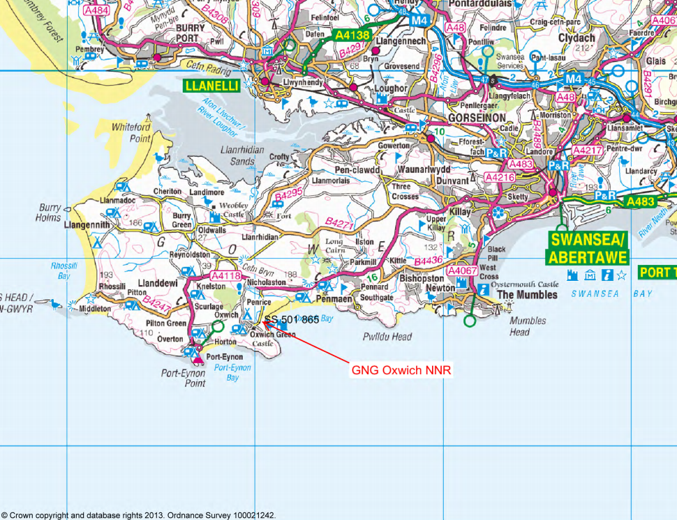
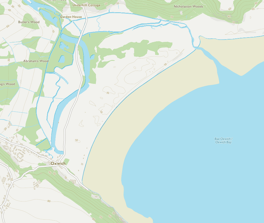
Definition: The local area you will walk around to collect your data. e.g. Oxwich Fore dunes.

Definition: The exact place where you will be standing to undertake the data collection method. e.g. 10m from the strandline.
 Further information
Mae angen lleoliad ar bob ymholiad. Disgrifiwch ble yr hoffech wneud eich gwaith maes. Defnyddiwch y penawdau hyn i'ch helpu. Cofiwch y gallwch ddychwelyd er mwyn ychwanegu'r union leoliad wrth i chi weithio drwy'r broses.
Trefol: Wedi'i leoli mewn ardal â dwysedd poblogaeth uchel.
Afon: Wedi'i leoli o fewn dalgylch afon ar system afon.
Arfordirol: Wedi'i leoli mewn ardal arfordirol rhwng y cefnfor a'r tir e.e. traeth.
Cynefin: Wedi'i leoli o fewn cynefin wedi'i enwi ag amodau amgylcheddol penodol. E.e. system twyni tywod, coetir, morfa heli, mynydd.
Anheddiad gwledig: Wedi'i leoli mewn pentref.
Ardal ddaearyddol: Lleoliad a gaiff ei gynnwys yn eich teitl a/neu eich is-gwestiynau e.e. Traeth Oxwich.
Safle: Y safleoedd lle y byddwch yn ymgymryd â gwaith samplu.
Pwynt Data: Yr union leoliad ar eich safleoedd lle y byddwch yn ymgymryd â'r gwaith casglu data.
Diffiniad: Disgrifiad eang o'r lleoliad. E.e. De Cymru, Gwarchodfa Natur Genedlaethol Oxwich.
Diffiniad: Yr ardal leol y byddwch yn cerdded o'i hamgylch er mwyn casglu eich data. E.e. Blaen-dwyni Oxwich.
Diffiniad: Yr union fan lle y byddwch yn sefyll wrth roi'r dull casglu data ar waith. E.e. 10m o'r draethlin.
Gwybodaeth bellach
Deciding what type of enquiry question(s) you are going to create will give you a framework to help plan. You will need to decide which of the five categories your location and geographical area of interest best fit into.
You may find you want to blend two types of enquiry; this is possible but you will need to be sure that you have a specific justification for this, otherwise the investigation may get too large and unfocused.
Bydd penderfynu pa fath o gwestiwn (cwestiynau) ymholi rydych yn bwriadu ei lunio (eu llunio) yn rhoi fframwaith i chi er mwyn helpu i gynllunio. Bydd angen i chi benderfynu pa un o'r pum categori sy'n gweddu orau i'r lleoliad a'r ardal ddaearyddol dan sylw.
Mae'n bosibl y byddwch yn penderfynu yr hoffech gyfuno dau fath o ymholiad; gellir gwneud hynny, ond bydd angen i chi wneud yn siŵr bod gennych gyfiawnhad penodol dros wneud hyn, neu gallai'r ymchwiliad fynd yn rhy fawr a cholli ei ffocws.
Warning! This resource is not optimised for use on mobile devices.
Rhybudd! Ni ellir defnyddio’r adnodd yma ar ffonau symudol neu dabled.
There are 5 different types of enquiry. Match the type of enquiry question to the definitions by dragging each one to its correct location.
Mae pump gwahanol fath o ymholiad. Parwch y math o gwestiwn ymholi â'r diffiniadau drwy lusgo pob un i'w leoliad cywir.
Well done. You have matched them all correctly.
Da iawn. Rydych wedi paru pob un yn gywir.
| Descriptive | This enquiry is focused on identifying what is happening through detailed description of the characteristics and/or behaviour of the sample population. |
| Comparative | A known geographical model or theory is compared with a specific location or time frame to analyse how applicable the model is. Alternatively, two different locations could be compared. |
| Explanatory | Primary focus is to explain relationships. Usually attempts to explain how the different variables relate to each other and asks why this happens. Often used to identify the extent and nature of cause and affect relationships. |
| Exploratory | Exploration of a situation or problem. Usually identifies key issues affecting a situation. Purpose is to understand more about the situation or problem. Often leads to further research. |
| Experiment | Uses control of variables to test the independent variable. Often uses hypothesis. Effects of variables are usually reduced in fieldwork by taking measurements at sites where significant dependent variables are similar. |
Terms Termau |
Definitions Diffiniadau |
Correct answers Atebion cywir |
|---|
A) Decide which types of enquiry questions you will use
An analysis of what is happening in a place or to a group of people. Often includes some descriptive aspects.
A known geographical theory or model is compared to a place OR two places are compared
Attempts to explain how different things (variables) relate to each other and asks why this happens
Exploration of a problem or issue affecting a place.
Uses control variables to run experiments to test an independent variable.
Dadansoddiad o'r hyn sy'n digwydd mewn man neu i grŵp o bobl. Mae'n aml yn cynnwys rhai agweddau disgrifiadol.
Caiff damcaniaeth neu fodel daearyddol hysbys ei gymharu â man NEU ddau fan.
Yn ceisio esbonio sut mae gwahanol bethau (newidynnau) yn gysylltiedig â'i gilydd ac yn gofyn pam bod hyn yn digwydd.
Archwiliad o broblem neu fater sy'n effeithio ar fan.
Mae'n defnyddio newidynnau rheoli i gynnal arbrofion er mwyn profi newidyn annibynnol.
B) Add extra information into the textbox, such as which model, issues or variables you might use.
A) Penderfynwch pa fathau o gwestiynau ymholi y byddwch yn eu defnyddio.
Dadansoddiad o'r hyn sy'n digwydd mewn man neu i grŵp o bobl. Mae'n aml yn cynnwys rhai agweddau disgrifiadol.
Caiff damcaniaeth neu fodel daearyddol hysbys ei gymharu â man NEU ddau fan.
Yn ceisio esbonio sut mae gwahanol bethau (newidynnau) yn gysylltiedig â'i gilydd ac yn gofyn pam bod hyn yn digwydd.
Archwiliad o broblem neu fater sy'n effeithio ar fan.
Mae'n defnyddio newidynnau rheoli i gynnal arbrofion er mwyn profi newidyn annibynnol.
B) Ychwanegu gwybodaeth ychwanegol yn y blwch testun, fel pa fodel, materion neu newidynnau y byddwch o bosibl yn eu defnyddio.
For the purpose of these activities we are using a title and sub-questions. You will need to create a title and some sub-questions for your own investigation.
Deciding on your enquiry question is an ongoing process through the planning. It is important to consider Data collection, Data presentation and Analysis when creating a title and a sub-question.
At ddiben y gweithgareddau hyn, rydym yn defnyddio teitl ac is-gwestiynau. Bydd angen i chi lunio teitl a rhai is-gwestiynau ar gyfer eich ymchwiliad penodol chi.
Mae penderfynu ar eich cwestiwn ymholi yn broses barhaus drwy gydol y cam cynllunio. Mae'n bwysig ystyried Casglu data, Cyflwyno data a Dadansoddi wrth lunio teitl ac is-gwestiwn.
Checklist for title:
If not go back and adjust or change it. You can do this at any stage during the enquiry process.
Further InformationRhestr wirio ar gyfer teitlau:
Os nad yw'n cynnwys gair o'r fath, dychwelwch ato a'i addasu neu ei newid. Gallwch wneud hyn yn ystod unrhyw gam o'r broses ymholi.
Gwybodaeth BellachCreate a draft title, using your geographical context, location and enquiry type. Remember your title could be written as a question.
Use a task word in your title.
 Download File
Use the example below to help you structure your title.
Geographical context: Perceptions.
Location: England, Derbyshire, Peak district National Park, Castleton, Cross Street.
Enquiry type: Descriptive.
An investigation to identify the different perceptions that people have when visiting Castleton honeypot in Derbyshire.
Lluniwch deitl drafft, gan ddefnyddio eich cyd-destun daearyddol, eich lleoliad a'r math o ymholiad. Cofiwch y gallech ysgrifennu eich teitl ar ffurf cwestiwn.
Defnyddiwch air tasg yn eich teitl.
 Lawrlwytho'r Ffeil
Defnyddiwch yr enghraifft isod i'ch helpu i strwythuro eich teitl.
Cyd-destun daearyddol: Canfyddiadau.
Lleoliad: Lloegr, Swydd Derby, Parc Cenedlaethol y Peak District, Castleton, Cross Street.
Math o ymholiad: Disgrifiadol.
Ymchwiliad er mwyn nodi'r gwahanol ganfyddiadau sydd gan bobl wrth ymweld ag ardal boblogaidd Castleton yn Swydd Derby.
Follow the steps in the table below to begin creating your sub-questions. Consider these success criteria. If you can’t fill in the sub-question confidently then you can go back and change your title.
|
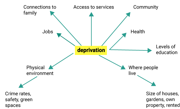
To what extent does deprivation impact people around central Bolton? |
|
|
|
Access to services: service provision Physical environment: environmental quality. Where people live: Housing |
Sub-questions:Does the amount of service provision change as we move away from the centre of Bolton? Does the environmental quality change as we move away from the centre of Bolton? Does the housing change as we move from the centre of Bolton? |
Dilynwch y camau yn y tabl isod er mwyn dechrau llunio eich is-gwestiynau. Ystyriwch y meini prawf llwyddiant hyn. Os na allwch chi lenwi'r is-gwestiwn yn hyderus, yna gallwch ddychwelyd a newid eich teitl.
|
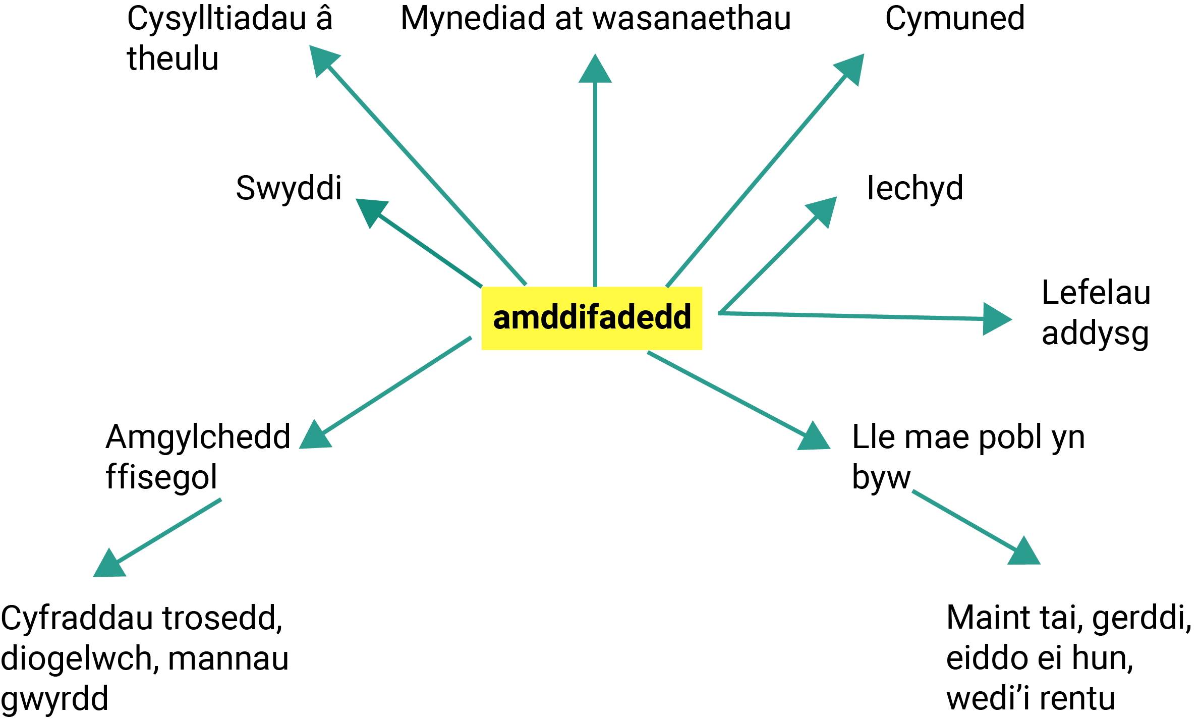
I ba raddau y mae amddifadedd yn effeithio ar bobl yng nghanol Bolton? |
|
|
|
Mynediad i wasanaethau: darparu gwasanaethau. Yr amgylchedd ffisegol: ansawdd amgylcheddol. Ble mae pobl yn byw: Tai. |
Is-gwestiynau:A yw nifer y gwasanaethau a ddarperir yn newid wrth i ni symud allan o ganol Bolton? A yw'r ansawdd amgylcheddol yn newid wrth i ni symud allan o ganol Bolton? A yw'r tai yn newid wrth i ni symud allan o ganol Bolton? |
You need some primary and secondary data to help you answer your enquiry, it could be qualitative or quantitative.
Your data is likely to be a sample of all the possible available data.
Bydd angen rhywfaint o ddata sylfaenol ac eilaidd arnoch i'ch helpu i ateb eich ymholiad, gallai fod yn ddata ansoddol neu feintiol.
Fwy na thebyg y bydd eich data yn cynnwys sampl o'r holl ddata posibl sydd ar gael.
Click on the button on the right to see your draft sub-questions. Identify the words that are relevant to collecting data. These are likely to be the Geography words that you choose for your sub-questions, which came from your mind-map. Remember you can go back to previous stages of the process to refine your answers, for example if you can’t identify variables from your question then refine your questions.
Now complete the table, an example has been done already.
Which age group has the most positive perceptions of X in the summer?
What information and evidence do you need to collect to answer your question?
This should link directly to the highlighted words in your title and sub-question.
Age groups into under 16, 16-21. 21-35. 35-50, over 50, so that a variety of age groups can be identified.
Perceptions of what people think about X, so I can see if X is more likely to appeal to a specific age group.
Which surveys, measurements or observations are you doing?
Give instructions that others could follow. Is it a group effort or on your own?
Questions using a Likert scale asking about feelings, environment and enjoyment.
Likert scale survey allows a range of perceptions from negative to positive.
Where are you going to stand to collect your data? Which website(s) will you use?
Along the main visitor centre walkway in X
You can’t measure everything, so what method are you going to use to decide what you can measure? Why pick this method?
Random sampling using number tables, as this helps eliminate bias, is simple and everyone passing has an equal chance of selection.
Have you got a data recording sheet that will enable you to record often and how many measurements you take?
What might go wrong with the plan? How could you overcome this while you are collecting your data? How will you record what you did?
Age groups might not be represented equally. Some people asked might not stop to answer, so I will ask the next person after them. Might not reveal their age, so I will guess & note how many people I had to guess for.
Cliciwch ar y botwm ar y dde i weld eich is-gwestiynau drafft. Nodwch y geiriau sy'n berthnasol i gasglu data. Mae'n debygol mai'r geiriau Daearyddiaeth fydd y rhain y byddwch yn eu dewis ar gyfer eich is-gwestiynau, a ddaeth o'ch map meddwl. Cofiwch y gallwch fynd yn ôl i gamau blaenorol y broses i fireinio'ch atebion, er enghraifft os na allwch nodi newidynnau o'ch cwestiwn yna mireiniwch eich cwestiynau.
Nawr cwblhewch y tabl, gwnaed enghraifft i chi'n barod.
Pa grŵp oedran sydd â'r canfyddiadau mwyaf cadarnhaol o X yn yr haf?
Pa wybodaeth a thystiolaeth y mae angen i chi eu casglu er mwyn ateb eich cwestiwn?
Dylai hyn gysylltu'n uniongyrchol â'r geiriau a amlygwyd yn eich teitl a'ch is-gwestiwn.
Trefnwch eich grwpiau oedran i gynnwys o dan 16 oed, 16-21, 21-35, 35-50, dros 50, er mwyn gallu nodi amrywiaeth o grwpiau oedran.
Canfyddiadau o'r hyn y mae pobl yn ei feddwl am X, er mwyn imi allu gweld a yw X yn debygol o apelio fwy at grŵp oedran penodol.
Pa arolygon, mesuriadau neu arsylwadau rydych yn eu cynnal?
Rhowch gyfarwyddiadau y gallai eraill eu dilyn. Ai ymdrech grŵp ydyw neu chi ar eich pen eich hun?
Cwestiynau sy'n defnyddio graddfa Likert yn gofyn am deimladau, yr amgylchedd a mwynhad.
Mae arolygon graddfa Likert yn golygu y gellir nodi amrywiaeth o ganfyddiadau, o rai negyddol i rai cadarnhaol – gweler yr enghraifft yn yr atodiad.
Ble rydych yn bwriadu sefyll er mwyn casglu eich data? Pa wefan/wefannau y byddwch yn ei/eu defnyddio?
Ar hyd y prif lwybr drwy'r ganolfan ymwelwyr yn X.
Ni allwch fesur popeth, felly pa ddull rydych yn bwriadu ei ddefnyddio i benderfynu beth y gallwch ei fesur? Pam dewis y dull hwn?
Samplu ar hap gan ddefnyddio tablau rhif, gan fod y dull hwn yn helpu i ddileu tuedd, ei fod yn syml a bod gan bawb sy'n mynd heibio yr un siawns o gael eu dethol.
A oes gennych daflen cofnodi data a fydd yn eich galluogi i gofnodi pa mor aml rydych yn mesur a sawl mesuriad rydych yn eu gwneud?
Beth allai fynd o'i le â'r cynllun? Sut y gallech oresgyn hyn wrth i chi gasglu eich data? Sut y byddwch yn cofnodi'r hyn a wnaethoch?
Mae'n bosibl na chaiff grwpiau oedran eu cynrychioli'n gyfartal. Mae'n bosibl na fydd rhai o'r bobl y byddwch yn gofyn iddyn nhw yn aros i ateb, felly byddaf yn gofyn i'r person nesaf sy'n mynd heibio. Efallai na fyddan nhw'n datgelu eu hoedran, felly byddaf yn dyfalu ac yn nodi faint o bobl y bu'n rhaid i mi ddyfalu ar eu cyfer.
You will need to present your data so that you can analyse it and look for patterns which help you answer your enquiry question.
Data should be presented in a variety of Cartographical, Graphical, Pictorial, and GIS forms.
Your data needs to be presented using the appropriate method.
Bydd angen i chi gyflwyno eich data er mwyn i chi allu eu dadansoddi ac edrych am batrymau sy'n eich helpu i ateb eich cwestiwn ymholi.
Dylid cyflwyno data mewn amrywiaeth o ffurfiau Cartograffigol, Graffigol, Darluniadol, a GIS.
Mae angen cyflwyno eich data gan ddefnyddio'r dull priodol.
Use your Data Collection table to identify which data you need to present. Use your sub-questions to identify which variables you need to present (link) together.
Complete the table, an example has been done already.
Sub-question: Which age group has the most positive perceptions of X in the summer?
This is likely to be two pieces of data within the same sub-question.
Flood prevention measures
Residential areas
Does your data have values that you can put on a graph?
Age group – In categories of age under 16, 16-21. 21-35. 35-50,over 50.
Perception of X – Quantitative on a scale 1 - 5
Qualitative
Photos
Field sketch
Sketch map
Discrete – Data in which each field is unconnected to and does not affect the data in any other field. Each piece of data is independent of each other. e.g. a count of different types of traffic.
Continuous (Interval) – Data that is measurable on a scale where each value is equal distance apart from each other. e.g. a measure of the temperature of a site each hour.
Continuous (Ratio) – Data that is measurable on a scale where each value is an equal distance apart from each other and where the data has a definite ‘zero’ or end value. e.g. a measure of the height of different trees along a transect line.
Categorical (Binary) – Data that falls into one or two mutually exclusive categories. e.g. a count of responses to a questionnaire that requires either a ‘Yes’ or ‘No’ answer.
Categorical (Ordinal) – Data that can be assigned to categories that have a rank or an order. e.g. a count of the responses to a survey question that asks respondents to rank something on a 1 to 5 scale.
Categorical (Nominal) – Data that can be assigned to categories that have no rank or order. e.g. a count of the number of individual plants of different species within a quadrat.
This is the relationship you want to try to show in your data presentation method.
Comparison between age groups.
Relationship
This could be
Justify why you have chosen this method linking back to your sub-question.
Radial graph
I have divided my age groups into 5 categories.
The data is not geospatially linked.
Map
GIS
Picture
I can show where the flood prevention measures, and the houses are on the same map or picture.
Graphs.
Looking for a correlation between two measured data sets, (Interval Data) – Scatter or Line graph. With few points - Histogram.
Comparing or looking for differences between data, Continuous interval or Categorical Nominal data – Bar charts, Box and Whisker, Radial Rose graph.
Showing the composition of your data, Categorical and Discrete data – Composite bar graphs, box and whisker, Pie chart.
GIS.
Data relates to an exact location point e.g. location on a beach, river – Dot Map, Proportional symbols.
Data relates to linear locations e.g. footpaths or streets, visitor journeys - Flowlines.
Data relates to an area e.g. wards, village, seral stage – Choropleth.
If you are selecting the data, then it is Independent.
If you are measuring or counting it in the field, then it is dependent.
Age Group – Independent
Perception of X - Dependent
Defnyddiwch eich tabl Casglu Data i nodi pa ddata y mae angen i chi eu cyflwyno. Defnyddiwch eich is-gwestiynau i nodi pa newidynnau y mae angen i chi eu cyflwyno (cysylltu) gyda'i gilydd.
Cwblhewch y tabl, gwnaed enghraifft i chi'n barod.
Is-gwestiwn: Pa grŵp oedran sydd â'r canfyddiadau mwyaf cadarnhaol o X yn yr haf?
Dau ddarn o ddata sy'n rhan o'r un is-gwestiwn fwy na thebyg.
Mesurau atal llifogydd
Ardaloedd preswyl
A oes gan eich data werthoedd y gallwch eu rhoi ar graff?
Grŵp oedran – Mewn categorïau oedran o dan 16 oed, 16-21, 21-35, 35-50, dros 50.
Canfyddiad o X – Meintiol ar raddfa o 1-5
Ansoddol
Ffotograffau
Braslun maes
Llinfap
Arwahanol – Data lle mae pob maes yn ddigyswllt ac nad ydyn nhw'n effeithio ar y data mewn unrhyw faes arall. Mae pob darn o ddata yn annibynnol ar ei gilydd. E.e. Cyfrif o wahanol fathau o draffig.
Parhaus (Cyfwng) – Data sy'n fesuradwy ar raddfa lle mae pellter cyfartal rhwng pob gwerth. E.e. Mesur o dymheredd safle bob awr.
Parhaus (Cymhareb) – Data sy'n fesuradwy ar raddfa lle mae pellter cyfartal rhwng pob gwerth a lle mae 'sero' neu werth terfynol pendant i'r data. E.e. Mesur o uchder coed gwahanol ar hyd llinell trawslun.
Categorïaidd (Deuaidd) – Data sy'n perthyn i un o ddau gategori cydanghynhwysol. E.e. Cyfrif o'r ymatebion i holiadur sy'n gofyn am ateb 'Ie' neu 'Na'.
Categorïaidd (Trefnol) – Data y gellir eu neilltuo i gategorïau sy'n rhestrol neu wedi'u trefnu. E.e. Cyfrif o'r ymatebion i gwestiwn arolwg sy'n gofyn i ymatebwyr restru rhywbeth ar raddfa o 1 i 5.
Categorïaidd (Enwol) – Data y gellir eu neilltuo i gategorïau nad ydynt yn rhestrol neu wedi'u trefnu. E.e. Cyfrif o nifer y planhigion unigol o rywogaethau gwahanol mewn cwadrad.
Dyma'r gydberthynas y dylech anelu at ei dangos yn eich dull cyflwyno data.
Cymharu grwpiau oedran
Cydberthynas
Er enghraifft
Cyfiawnhewch pam eich bod wedi dewis y dull gan gyfeirio at eich is-gwestiwn.
Graff rheiddiol
Rwyf wedi rhannu fy grwpiau oedran yn 5 categori.
Nid oes cysylltiad geo-ofodol rhwng y data.
Map
GIS
Llun
Gallaf ddangos lleoliad y mesurau atal llifogydd, ac mae'r tai ar yr un map neu lun.
Graffiau.
Yn chwilio am gydberthyniad rhwng dwy set o ddata wedi'u mesur (Data Cyfwng) – Graff gwasgariad neu graff llinell. Yn cynnwys nifer fach o bwyntiau – Histogram.
Yn cymharu neu'n chwilio am wahaniaethau rhwng data, data Cyfwng Parhaus neu ddata Categorïaidd Enwol – Siartiau bar, Graff Blwch a Blewyn, Graff Rhosyn Rheiddiol.
Yn dangos cyfansoddiad eich data, data Categorïaidd ac Arwahanol – Graffiau bar cyfansawdd, Blwch a Blewyn, Siart cylch.
GIS.
Mae'r data yn ymwneud ag union bwynt lleoliad e.e. lleoliad ar draeth, afon – Map Dotiau, Symbolau cyfrannol.
Mae'r data yn ymwneud â lleoliadau llinol e.e. llwybrau troed neu strydoedd, teithiau ymwelwyr – Llinellau rhediad.
Mae'r data yn ymwneud ag ardal e.e. Wardiau, pentref, cam seral – Cloropleth.
Os ydych yn dethol y data, mae'n annibynnol.
Os ydych yn eu mesur neu'n eu cyfrif yn y maes, yna mae'n ddibynnol.
Grŵp Oedran – Annibynnol
Canfyddiad o X – Dibynnol
Analysis means examining your data and making sense of all your evidence. The way in which you plan to analyse your data may affect how you sample or collect your data or the type of data you need.
Qualitative and quantitative data can be analysed differently.
What statistical test does the task word relate to?
Look at the task words you are using in your sub-questions to identify the appropriate data analysis technique.
What opportunities does your title open up for high quality analysis?
Use the table below to help.
| Data | Examples | Things you might be looking for | Example methods |
|---|---|---|---|
| Qualitative | Images such as photos, video or field sketches. | Features, characteristics that have meaning in the images. |
|
| Qualitative | Text, words, transcripts, news articles, diaries. | Patterns and trends in the words, as well as anomalies. |
|
| Quantitative | Spatial data, distribution data. | Patterns. |
|
| Quantitative | Temporal or numerical data. | Trends, sequences, patterns and correlations. Most common data, proportions or frequency of data. |
|
Ystyr dadansoddi yw archwilio eich data a gwneud synnwyr o'ch holl dystiolaeth. Gall sut rydych yn bwriadu dadansoddi eich data effeithio ar sut y byddwch yn samplu neu'n casglu eich data neu'r math o ddata sydd eu hangen arnoch.
Gellir dadansoddi data ansoddol a data meintiol mewn ffordd wahanol.
Pa brawf ystadegol y mae'r gair tasg yn gysylltiedig ag ef?
Edrychwch ar y geiriau tasg rydych yn eu defnyddio yn eich is-gwestiynau er mwyn nodi'r dechneg dadansoddi data briodol.
Pa gyfleoedd y mae eich teitl yn eu cynnig ar gyfer gwaith dadansoddi o ansawdd uchel?
Defnyddiwch y tabl isod i helpu.
| Data | Enghreifftiau | Pethau y gallech chwilio amdanyn nhw | Dulliau enghreifftiol |
|---|---|---|---|
| Ansoddol | Delweddau fel ffotograffau, fideos neu frasluniau maes. | Priodweddau, nodweddion sy'n cyfleu ystyr yn y delweddau. |
|
| Ansoddol | Testun, geiriau, trawsgrifiadau, erthyglau newyddion, dyddiaduron. | Patrymau a thueddiadau yn y geiriau, yn ogystal ag anghysondebau. |
|
| Meintiol | Data gofodol, data dosbarthu. | Patrymau. |
|
| Meintiol | Data amseryddol neu rifiadol. | Tueddiadau, dilyniannau, patrymau a chydberthyniadau. Y data mwyaf cyffredin, cyfrannau neu amledd data. |
|